Double Hammock Creek
See trail guide below ... click on camera icons for photos at that location.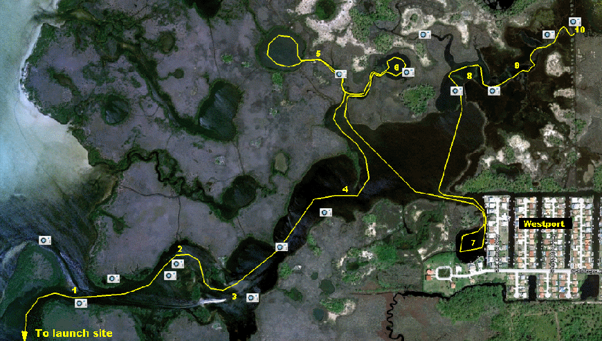
The Double Hammock Creek paddle trail is an ambitious journey into the largest creek in the Park. If you follow our route, which includes some interesting sidetrips, you will paddle almost 6 miles into the headwaters of Double Hammock Creek. You will probably elect for a more direct return trip. But the total distance will probably be about 11 miles - so plan to take your time and spend the best part of a day. Be sure to bring plenty of water, sunscreen, and maybe your lunch.
Most of this trip may be made at any tide level - although more water is better. The waterway to the lake beyond point 5 will require about 2 feet of tide. And a high tide will also allow you to push further upstream if that is your interest.
Another consideration for this trip is the wind. Part of your trip will be through open Gulf waters. So if the wind is blowing more than 10 mpg, plan to get wet. If the wind is from the east, a windy day is probably okay since you will be hugging the shoreline. But even then, you could encounter whitecaps while crossing the wide mouth of Salt Springs Run, and in sections of Double Hammock Creek.
Hidden along Double Hammock Creek is a series of 18 geocaches. See HERE for more information.
The kayak launch is located at the end of the Kayak Launch Trail accessible from the main parking area. Another convenient launch point is Brasher Park, at the west end of Koons Drive in Port Richey, FL. The trail map above does not show the entire journey from the launch site. It is about 1-1/2 miles from the launch point to the south entrance of Double Hammock Creek. If you go at a very low tide, you may have to paddle around the outside of Cow Key, which is offshore from Brasher Park.
- Enter Double Hammock Creek from the south. Or if you prefer, you can paddle around the outside of the island at the mouth of the creek and come in through the Westport Channel.
- Hugging the north shore of Double Hammock Creek you may see a narrow airboat path heading to the north. At high tide, this is passable with a kayak or canoe, and opens into another small creek.
- Around the tip of the point and to the south you can see an inlet that leads to Alligator Pass. This is the route you would take to follow the south branch of Double Hammock Creek - but that's another trip.
- A long pinensula formed of mangroves and oyster beds block your way and you have to loop around the south. Tidal flow draining from the two lakes to the north almost certainly helped form this natural curtain that extends into Double Hammock Creek. As you paddle around the tip and head northeast, you will enter the widest part of the Creek - a good place to watch for dolphin and manatees.
- Heading north into a tributary of Double Hammock Creek, you will go left at the fork. Just before you reach the large 600 foot diameter lake ahead, there will be a shallow section that will require about 2 feet of tide for passage. If the tide is running out, the current here could be challenging for novice paddlers. If you make it into the lake a full high tide, there is a narrow passage that extends west from the lake into Pound Net Creek and the Gulf. For now, just enjoy the lake and leave the same way you came.
- When you get back to the fork in the stream, turn left and explore the other lake to the northeast. This lake, and the one you visited previously, are almost perfectly circular in shape, and are common in Werner-Boyce Salt Springs State Park. The origin of these lakes is a subject of speculation - they could be formed by sinkholes or springs - some even say the area was once a military bombing range, although no one has found evidence of that being the case.
- After leaving the lakes, paddle all the way across Double Hammock Creek to the entrance of a large residential area named Westport. This area was developed long before anyone really thought about saving environmentally sensitive lands. As such, the development juts out into the Park and effectively divides the land area of Werner-Boyce Salt Springs State Park into a north and south section. The lake at the west end of Westport is another one of those "circular" lakes that now has concrete seawalls along several sides. There is a passage leading out of this lake to the west that runs around the house on the point. Although only passable with a moderately high tide, and with the way largely blocked by mangrove branches, it does come out on the south side of Westport near the creek that is fed by Gar Spring.
- As you proceed upstream, you'll see another tributary running in from the north. With an extremely high tide, you can fight through narrow passages in the Needle Grass and come to another lake. Only die-hard adventurers should attempt this route - you may end up having to back all the way out.
- The Creek turns into a meandering stream with lots of paths to follow. It's pretty easy to get turned around in here, so just follow the flow of the water. The trail will get narrower and narrower as you go on.
- Providing you have enough water, you will eventually come to a narrow waterway that runs due north and south. This is a man-made canal constructed for a purpose that is lost in obscurity, but it was probably a ditch used for mosquito control drainage. Brave or foolhearty souls may proceed further into the grass along narrow passageways - but for all practical purposes, this is about as far as you can go.
After completing the paddle trail, the trip back will be a bit shorter without all the side trips. If you have timed your trip to start with an incoming tide, maybe you'll be lucky and have a receding tide to help you back to the launch point.